03.06.-09.06.2019
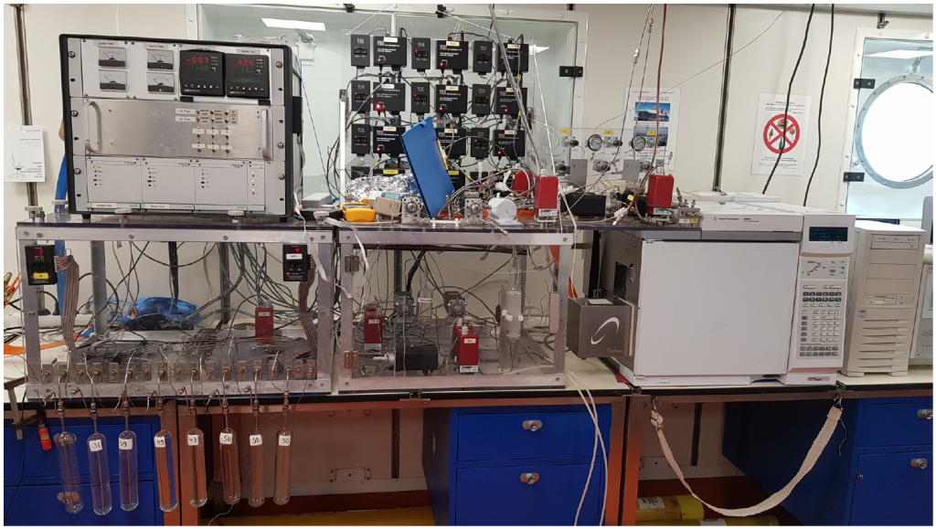
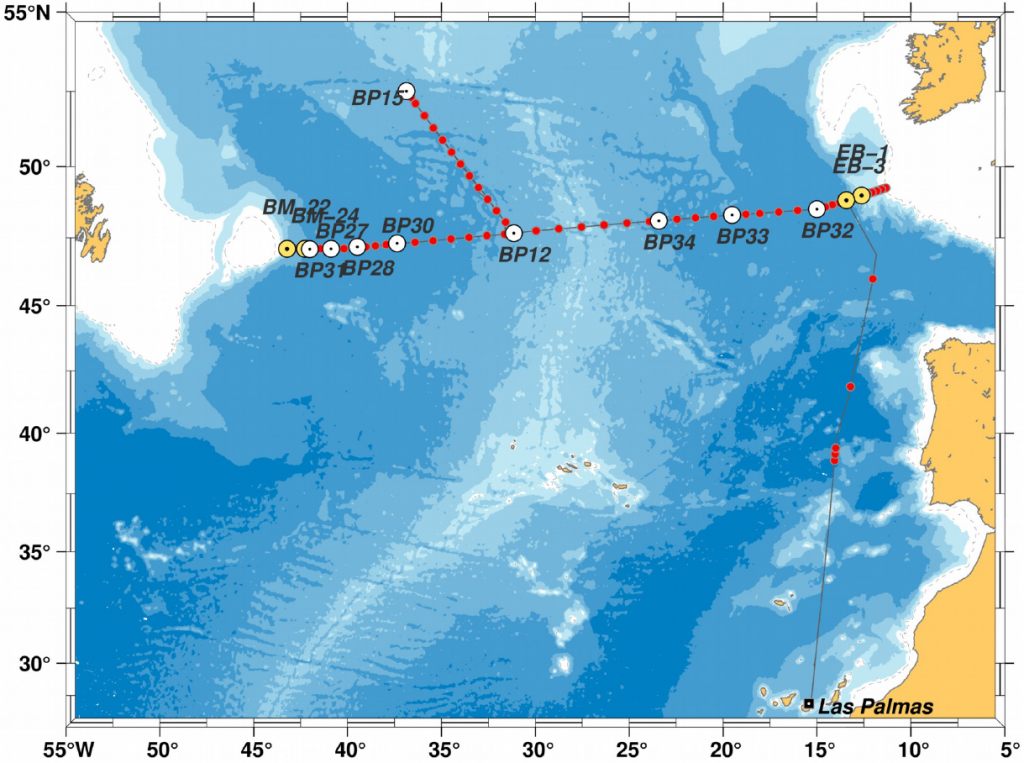
In the 4th week of the MSM 83 cruise we carried out measurements along the western part of the hydrographic section along 47°N, from the Mid-Atlantic Ridge to the continental slope at the Flemish Cap. For this purpose, the CTDO probe, which records the pressure, temperature, salt and oxygen content of the water, was lowered to the seabed at 30 stations and brought back to the deck. In two depth ranges, the salinity shows a pronounced minimum: in a layer directly above the seafloor and in a range of 1500 to 2000 m depth. At these locations, the oxygen content is increased at the same time. This indicates that the water had contact with the atmosphere a few years ago, and thus could take up oxygen from the atmosphere. The water in the bottom layer originates from the Nordic Seas and passes through the Denmark Strait located between Greenland and Iceland into the subpolar North Atlantic. Due to its high density, the water sinks after leaving the Denmark Strait to the seabed and spreads out on the ground. Another area where water sinks from the surface of the sea is the Labrador Sea. Due to high heat losses in the winters since 2014, the water column has been mixed to depths of 2000 m and enriched with oxygen. This water has spread to the south in recent years and can be identified on our 47°N section by its low salt and high oxygen content. A comparison of the data of this cruise with the past years shows that the Labrador Water formed since 2014 has already advanced over the Mid-Atlantic Ridge into the Eastern Atlantic. Also, the gas concentrations of chlorofluorocarbons (CFC) and sulfur hexafluoride (SF6) measured with the gas-chromatographic analysis system indicate the presence of newer deep water.
At a total of 6 so-called super-stations, we also took water samples for the determination of 39argon and tritium in the ocean in addition to samples of trace gases and oxygen. While CFC and SF6 are useful markers for the identification of water masses formed in the last 70 years, 39argon and tritium serve to identify water masses that are up to 200 years old. With the help of this data, which are measured and evaluated in the laboratories of the University of Heidelberg and Bremen, we want to determine the exchange and mixing of new and old water masses. The gaschromatographic system provides very good data, and we are very pleased with the data yield.
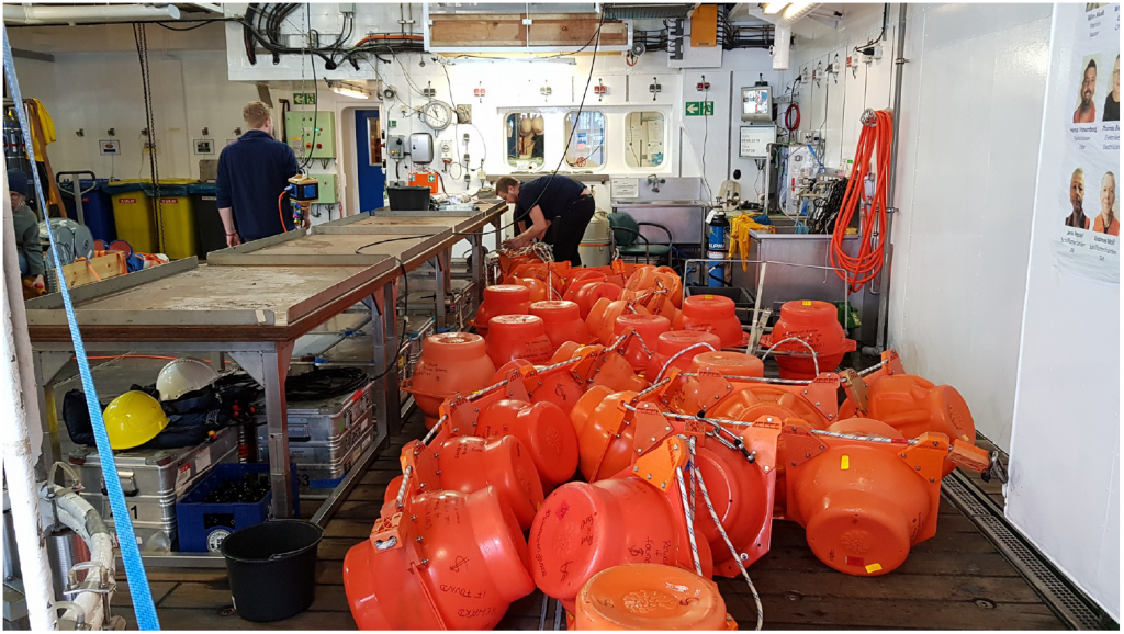
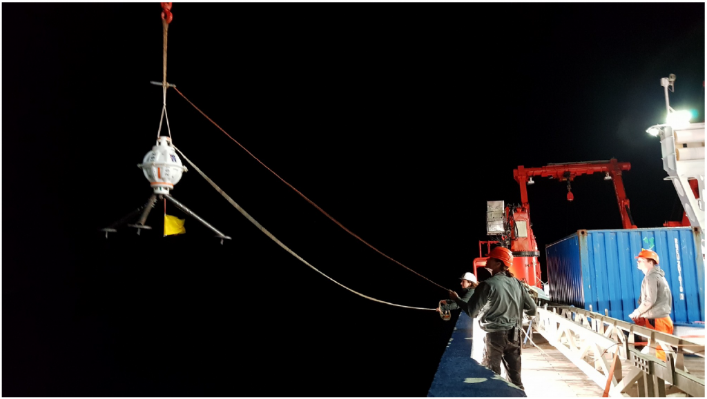
Heading west, we visited PIES positions BP-27, BP-28, BP-30 and BP-31 in the Newfoundland basin this week. We have received the corresponding measurement data from all but one PIES. The communication with PIES BP-31 unfortunately did not work out fine on Saturday evening. Since we were surrounded by a dense fog wall at night, we did not want to risk a recovery attempt. On Pentecost Sunday, the recovery of the moorings BM-22 and BM-24 was imminent. These two deep-sea moorings are installed in the core areas of the deep western boundary current and serve the purpose of measuring the cold low-salinity currents coming from the north. From this data we want to make statements about how much subpolar water, especially deep water, crosses the 47°N latitude. National and international teams are surveying the western boundary current farther north in the Labrador Sea and further south, e.g. in the subtropics. Our measurements close an important spatial gap, and our data should among others give information on how variable the strength of the boundary current on the way from north to south is or what the temporal fluctuations look like. Similar to the moorings located near the Irish shelf edge the two deep-sea moorings of Flemish Cap were deployed last spring with RV Maria S. Merian (cruise MSM 73). This weekend, our course led repeatedly through pronounced fog fields. When we talked via the hydrophone on Sunday morning to the acoustic release of mooring BM-22, we found a gap in the fog cover just in time and good visibility for our purposes. These conditions even improved during the day. The acoustic release is attached to an anchor stone and holds the whole mooring in place. After the hook is opened, to which the anchor stone is attached, all instruments float thanks to the built-in buoyancy bodies to the surface, where we could then collect everything. The moorings BM-22 and BM-24 could thus be recovered successfully, and we are now in the process of viewing and saving the recorded measurement data. At the same time, the next mooring for the new deployment period was prepared. All measuring instruments therefore needed to be examined for damage and supplied with fresh batteries. All ropes and fittings were inspected for any cracks or corrosion damage. Finally, on the night of Whitsun Monday, we made a new attempt to recover the PIES BP-31. Unfortunately, success has failed, and we must consider BP-31 lost. We have installed a new PIES at this location, so that the measuring chain is complete again along 47°N. The remaining time aboard the Maria S. Merian we spend completing the mooring work and the remaining hydrographic program. A mooring recovery in the Flemish Passage west of the Flemish Cap is still pending as is the deployment of a mooring on the east side of the Flemish Cap, more on that in the last weekly report. Greetings on behalf of all cruise participants,
Dagmar Kieke (Chief Scientist)